Sunday, December 30, 2007

MMMM....My Annual Holiday Dinner--For The First Time!

My mother...every Saturday following Christmas...makes this Holiday dinner and this was my first year headed there.

It was AMAZING!!! I mean, I've never tasted more delicious food.

The Meal:

Appetizer:
  • shrimp cocktail
  • salmon
  • crackers/cheese
  • veggies
  • HOMEMADE dip (yum!)

Dinner:

  • pork
  • duck ... my appologies to any vegetarians
  • potatoe salad
  • rice
  • potatoes (roasted)
  • veggies cooked

Desert:

  • fruit
  • AND MY NEW FAVOURITE...The World's Best Homemade/Handmade Tiramisu (my mom's was better than the picture)

Thanks mom for Everything! Dinner was delicious...amazing...wonderful! Can't wait till next year. With love forever mommy!

Chris

Weather Specialist

PS: I'll have a weather blog tomorrow.

Wednesday, December 26, 2007

HOLIDAY FORECAST


This blog's photographs and forecasts is provided by The Weather Network.
Let's start with the Holiday Forecast. The link provided gives you the 14-day trend, Holiday travel and how to manage STRESS! To check another city, other than Toronto for your holiday forecast, click here.
The average high temperature for New Year's Eve is -1.1C, the average low is -9.2C and the average precipitation is 1.9mm. It's predicted that the temperature will be -4C, which is in the middle. Holiday Safety Tips and the 14-day trend can be found here.
Wishing you a great Boxing Day trip...whether it'd be shopping or staying at home!!
Chris
PS: I'll be blogging a lot before '08, we are trying to reach 100 Blogs by the end. So far, we're at 88.

Tuesday, December 25, 2007

Most Are Off....Some Are Still Blogging

I know for a fact that most meteorologist's are off for the Holidays. Except for me. I have my holidays: Christmas, New Years and about one or two days within the two weeks, but other than that, the blogs are on me.

Truth be told, Christmas is my favourite time of year--the weather, but most of all...the time we spend with our families. My gift to you is a prayer to keep the true meaning of Christmas:

A Christmas Prayer by Robert Louis Stevenson

Loving Father, Help us remember the birth of Jesus, that we may share in the song of the angels, the gladness of the shepherds, and worship of the wise men.
Close the door of hate and open the door of love all over the world. Let kindness come with every gift and good desires with every greeting. Deliver us from evil by the blessing which Christ brings, and teach us to be merry with clear hearts.
May the Christmas morning make us happy to be thy children, and Christmas evening bring us to our beds with grateful thoughts, forgiving and forgiven, for Jesus' sake. Amen.


May the spirit of Christmas be with you and your family. From my home to yours...

Chris

Merry Christmas!!

Saturday, December 22, 2007

Your Christmas Forecast

TORONTO:
With temperatures warming up, the chances of a White Christmas are slim--although the White Christmas production is playing at the Sony Centre.

To the forecast: for Christmas Eve Day, we'll see some white flurries--no major storm--with highs of -1C. For the Eve, we'll see temps at around -6C. Winds will travel at 40km/h...so keep those presents tight. For Christmas Day, we'll see some PARTLY cloudy skies with temperatures reaching a high of 0C. The lows will be -5C. Winds calm down to 15km/h. Boxing Day, not only will it be hectic but also warm with highs of +1C.

All in all, we'll see a good Christmas forecast, but it could change in a flash. I'll keep you updated with recent changes.

I invite you to take a look at some of the Best Christmas Houses from Michael Kiss' blog.\

Happy Holiday's...from my family to yours!

Chris

Weather Specialist/Meteorologist

CityWeather

city.weather@yahoo.ca

Monday, December 17, 2007

What Happened This Weekend?

Did everyone enjoy the 20 centimetres of snow?

Stop and think for a minute that in Nova Scotia, they've been getting snow for 15 days straight...and the snow banks reach their houses.

Back in Toronto, many were out cleaning and shoveling. I'm seeing a "vague" low coming through which may mean for a storm on Sunday....


GOTTA GOOO!!! RUN!!!!!


Chris

Friday, December 14, 2007

Snow Update I.

Here comes the snow-all dressed in white. That makes sense for what is about to happen.


Courtest of The Weather Network, here are the updates.


Issued by ENVIRONMENT CANADA
Winter storm watch for: City of Toronto
Issued at 3:14 PM EST FRIDAY 14 DECEMBER 2007
..MAJOR WINTER STORM APPROACHING SATURDAY EVENING.. THIS IS AN ALERT TO THE POTENTIAL DEVELOPMENT OF DANGEROUS WINTER WEATHER CONDITIONS IN THESE REGIONS. MONITOR WEATHER CONDITIONS..LISTEN FOR UPDATED STATEMENTS.
A MAJOR WINTER STORM CURRENTLY DEVELOPING IN TEXAS WILL MAKE ITS WAY NORTH TOWARDS SOUTHWESTERN ONTARIO SATURDAY AFTERNOON. SIGNIFICANT SNOWFALL ACCUMULATIONS OVER THE REGIONS ARE LIKELY SATURDAY NIGHT THROUGH SUNDAY. IT IS POSSIBLE WINTER STORM WARNINGS WILL HAVE TO BE ISSUED FOR SOME REGIONS DUE TO LOCAL SNOWFALL ACCUMULATIONS OF 25 CENTIMETRES IN LESS THAN 24 HOURS. THE HIGHEST SNOWFALL AMOUNTS WILL LIKELY BE IN THE HAMILTON AREA WHERE EMBEDDED LAKE EFFECT SNOW WILL ADD TO THE MOISTURE OF THE SYSTEM. THERE WILL ALSO BE SIGNIFICANT BLOWING SNOW AND POSSIBLY FREEZING RAIN OVER THE REGIONS. THE SNOW WILL SPREAD NORTHWARD AND EASTWARDS OVER MOST OF SOUTHERN ONTARIO SATURDAY NIGHT AND THROUGH SUNDAY MORNING. THIS WILL MAKE TRAVEL ON THE ROADS EXTREMELY HAZARDOUS AND TRAVELLERS ARE ADVISED TO USE EXTREME CAUTION SATURDAY NIGHT AND SUNDAY IF THEY HAVE TO USE THE ROADS. ENVIRONMENT CANADA IS MONITORING THE SITUATION CAREFULLY AND WILL ISSUE THE APPROPRIATE WEATHER WARNINGS AS THE STORM EVOLVES. STAY TUNED FOR FURTHER UPDATES.PLEASE REFER TO THE LATEST PUBLIC FORECASTS FOR FURTHER DETAILS.

Also, go to www.citynews.ca and click on BLOGS and follow the links to weather. www.CityNews.ca/weather has updates as well.

Stay tuned for Part II.

Chris

Weather Specialist (Meteorologist in Training)

PS: I'd love to see your pics. Send them to city.weather@yahoo.ca. I've been assigned to 24 hour on-call, meaning I need to be up when I'm needed for the Storm Watch. I'll be blogging continuously.

I'm also off from December 18 to 21.

Friday, December 7, 2007

THE HIT WEEKEND

The Daily Bread Food Bank.

Christmas Time.

HELP!

There are several out there who use and need the Daily Bread Food Bank and they need your help. For every one person who has a Christmas dinner, seven don't!

Donate. Food or funds. Anything. Just help...please!

My personal goal is to collect 1000 lbs of food...

My hit weekend is December 14-17. Make it yours too!


www.dailybread.ca

Friday, November 30, 2007

THE WINTER STORM...THAT KEEPS ON COMING: My Story - Part I

I'll have a huge story for you coming up tonight in regards to the GTA's and Ontario's "big storm" that is predicted to come. Doing some research and checking my emails now. Check out for my story and neat links coming up before 11:59:59pm Tonight.

Email me with your pics and stories...

city.weather@yahoo.ca

Saturday, November 24, 2007

YOUR SNOWFALL PICTURES: STILL NEEDED

We're trying to break our first record at CityWeather: the attempt to get thirty snowfall pictures. The final date to send them in is FRIDAY, NOVEMBER 30, 2007 @9:00 pm. We'll post them up on Monday.

Have a great weekend

Chris


city.weather@yahoo.ca

Thursday, November 22, 2007

SNOW CENTRE: NOW OPEN

SEND IN YOUR SNOW DAY PICTURES TO CITY.WEATHER@YAHOO.CA AND THEY'LL BE POSTED IN OUR SNOW CENTRE. now open.

Monday, November 12, 2007

SNOW IN THE FORECAST...AND FRANK'S BACK!!

Heavy rain with highs of 14C on Wednesday brings snow in the forecast for Thursday with a high of 6C low of 3C. But the snow continues on Friday with highs of 5 but this time a low of -1C. Notice the "-". Clears up to be partly cloudy on Saturday but the heavy rain comes back on Monday with highs of 8C. The Full Forecast is available by clicking here.

"Terrific Tuesday Follows Monsoon Monday"


And BreakfastTelevision's Frank Ferragine is back from his honeymoon in Jamaica. To see some "BT Bites", click here and make sure to watch A Feline Frenzy clip for the honeymoon.

Chris

Weather Specialist -- soon to become Meteorologist...

Thursday, November 8, 2007

WINTER WHITE: PART I - Need Your Emails!

If you live in Barrie, Aurora or anywhere up North....please email me RIGHT NOW!!! city.weather@yahoo.ca

LET ME KNOW: if you have snow, and how much

Did you know that Barrie got about 5cm of snow today? And Toronto got some flurries, too!!

Email me with pics and fun stuff...facts too! I'll post them on my blog tomorrow. It'll be called "WINTER WHITE: PART II - VIEWERS"

Thanks.

city.weather@yahoo.ca

Chris

Meteorologist

CityWeather

Sunday, November 4, 2007

The Cold Is Giving People A Cold

I have a cold. My friends had a cold. My mom is getting a cold. You get the picture.

Studies have shown that a change in season and partial drastic change in temperature affects people's immune system. But I'm not a health specialist, rathermore a weather specialist.

Monday is calling for rain with a high of 10C, which isn't that bad--but the low is 1C. Tuesday's high is 7C with partly cloudy conditiions. Wednesday has the same conditions but one degree lower with the high and low of 6C and 0C. But Thursday we dip down to a low of -1C and highs of 4C. Sunny skies with a high of 6C on Friday...low of -1C and cloduy on Saturday with the same temperatures as Friday.

Hoping all those who get sick....gets well soon!!

Record October. Seasonal November


city.weather@yahoo.ca

Friday, November 2, 2007

IT'S GOING TO GET COLDER!!

iT'S GOING TO GET REALLY COLD!!

I'll tell you how much and when coming up on MONDAY!

Thursday, November 1, 2007

With The Holidays Just Around The Corner...

This blog is devoted entirely to supporting the Holidays...

We're all teaming up to give to those who don't have but need!!

There are several charities that are in need of YOUR HELP and we're helping, too! It's a time of giving so no matter what holiday's you are celebrating there is one charity that needs YOUR HELP!! This will probably be the first and last (until next holiday season) that I am writing this blog and begging on my knees!!

A LIST OF CHARITIES THAT YOU CAN SUPPORT:

  • Breakfast Television is teaming up and singing their hearts out in support of the Daily Bread Food Bank. Take a look at what they're singing about in the Holiday soundtrack "BT Holiday Favourites" by going to http://www.citytv.com/micro/btholidayfavourites07/

And there are many more that need your help. Email me with charities that YOU support!!

Chris......Happy Hoildays!

Monday, October 29, 2007

CONGRATULATIONS!!!!!!!!

CityWeather would like to congratulate Breakfast Television's own Frank Ferragine (AKA Frankie Flowers) on his celebration of marriage. Click here to see some 'coverage'.

Halloween is creeping around the corner.

Wednesday, October 24, 2007

ONE WEEK TO HALLOWE'EN!

With one week to go until the spooky night, you can betcha that most people are asking "What's the weather going to be like".Well if you're going to take the little ones out, I'm working on a story that will help the weather cooperate with you. Right now though, we're going to a low of 0 on the night BUT that's later on. Around 7-9pm it'll be about 5C.

We're actually right now on a roller coaster of weather. I like to call this one "PSYCLONE". I'll talk more about this in my next entry.

If you have a weather question, email me at city.weather@yahoo.ca

PS: Send me your halloween costumes and I'll be sure to post them on the 31st.

Friday, October 19, 2007

PLANNING OUT A PERFECT WEEKEND?!

Today was BUSY in terms of weather. Quite gusty as well. The winds continue tomorrow. Tonight we'll go down to a clear low of 12C. Tomorrow, though will be probably the same type of conditions (cloudy) but with a high of 16 C. Sunday though, sunny skies with a high of 21 C and a low of 11C. Monday when it's time to head back to work/school, will be fair skies with a high of 22C and a low of 12C. The weather pattern is on a roller coaster.

Sorry I haven't been blogging everyday, things have been sooo busy!

Chris

Monday, October 15, 2007

YOUR QUESTIONS ANSWERED

I'm sorry I haven't been blogging for a while-internet connection down, and blogger is under maintenance.

A lot of you have sent me emails asking questions and I generally answer them back via email, however I have taken a few questions so here they are...your Q's A's.

Why is Toronto often warmer than its surroundings?

This is known as the heat island affect. Due to the heat given off by buildings vehicles and people in a large city like Toronto and the heating by the sun of a city's dark surfaces like pavement the temperature can be 1C to 2C warmer in the day than if the city wasn't there. At night it's even more dramatic. On a calm, clear night temperatures can be as much as 12C warmer.

What's the difference between a meteorologist and a weather specialist?

A meteorologist is someone with a four year degree in meteorology or atmospheric science. A weather specialist is someone with weather knowledge but hasn't studied or completed specific course work in the discipline.

What is dewpoint?

Dewpoint (Td) is the point at which the air must be cooled to to become totally saturated. If the temperature is below freezing it is sometimes called the frost point. As the air temperature gets closer to the dewpoint temperature the humidity increases. Once the temperature dips to meet the dewpoint temperature and the air becomes totally saturated the water vapour starts to condense into water droplets. When this happens at the surface we get fog.

When will temperatures get back to normal?

It looks like we'll see more fall-like weather next week. Temperatures will heat up again from now until the weekend but start to become unsettled and more seasonal by the middle of next week. A low pressure system looks like it's finally going to pull a little of the cold air into Ontario from the western provinces.

Will we have a snowy winter?

Expect more snow than last year. A La Nina winter is shaping up. That normally results in near seasonal temperatures and above normal precipitation.


There you have it. Enjoy the climate change .

CHRIS: city.weather@yahoo.ca

Wednesday, October 10, 2007

Tuesday, October 9, 2007

YOUR DEMOCRATIC DUTY AND THE WEATHER

ONTARIO (TORONTO):

Tomorrow it is time to perform your democratic duty: vote for the Premier of Ontario. The weather, however, won't be an excuse.

It will be a little chilly across the northwest as a
rainmaking low exits the area early in the morning. Areas from Thunder Bay
to Timmins will see a few light morning showers and then cloudy conditions by
midday. High temperatures will hover near 10C which is fairly close to
normal. Across central Ontario the light showers will hang on into the
afternoon. Temperatures still look good though topping out near 14C.
Around the GTA the temperatures won't get much warmer than that but showers will
be very light and spotty. I recommend an umbrella but you may not need it
much or at all. When the polls open the temperature will be a comfortable
10C with some sunny breaks in Toronto. By noon the mercury will hover near
14C and hang there until about 5 PM before slowly fading to about 12C by the
time the polls close. Eastern Ontario will be a little warmer with highs
as toasty as 18C. Showers are also in the forecast from Ottawa to
Kingston with most of the wet weather coming later in the day.

When you head to the polls tomorrow, open from 9AM to 9PM, tote along an umbrella...but not a winter coat.

Have a great voting day,

Chris

PS: I hope all of your Thanksgiving's were harvestful and enjoyable. Be thankful for all! Including the nice weather.

Sunday, October 7, 2007

HAPPY THANKSGIVING!

Happy Thanksgiving all! I'll be back blogging Tuesday.

Sunday, September 30, 2007

Fall-iday

I'm headed on my seasonal holidays, or for fall I like to call it a Fall-iday. I'll be back blogging on October 9th...after Thanksgiving. Have a great Thanksgiving holiday.

Go to citynews.ca for forecasts.

Chris - city.weather@yahoo.ca

Friday, September 28, 2007

We Want YOUR Weather Forecasts!

Here's your chance to be the forecaster for your city on CityWeather.

Over the weekend, we want YOU to come up with Monday (October 1st) forecast. You may need research. We want the actual forecast BUT in your terms. For example, if it calls for 24 on the Weather Channel, and you THINK it will be only a high of 19, write that!

THE TRICK: It is based on histrorical weather data and the past week's forecast.

Send all your forecasts into city.weather@yahoo.ca by 6:00pm on Sunday evening. Have a great weekend!

Chris

Tuesday, September 25, 2007

RAIN IN THE FORECAST?

There is a slight chance of rain heading into Toronto forecasted for within the next 24 hours.
Chris

Friday, September 21, 2007

Cloud In A Bottle

Ever wonder how clouds are formed? Click here to make your own cloud.

I'll have the outlook on the Second Day of Fall back on Monday for you. Remember that Fall officially arrives at 5:51 am Sunday morning.

Click here to see the weekend outlook by Michael Kuss.

Have a fantastic weekend.

Thursday, September 20, 2007

WHAT IS A "JET STREAM"?

I've actually got quite a few emails asking me what a "jet stream" is. A jet stream is an area of strong winds that are concentrated in a relatively narrow band in the upper troposphere of the middle latitudes and subtropical regions of the Northern and Southern Hemispheres. Flowing in a semi-continuous band around the globe from west to east, it is caused by the changes in air temperature where the cold polar air moving towards the equator meets the warmer equatorial air moving polarward. It is marked by a concentration of isotherms and strong vertical shear.

TORONTO:

Tonight's Outlook: This evening we'll go to 21C with clear skies and 10km/h winds. Though tonight we'll come in touch with foggy skies and temperatures of 14C with 5km/h winds...and early morning Friday will be foggy with 14C temps, also. But by the afternoon we'll go all the way up to 27C with some cloudy periods and 10% chance of rain. It'll feel like 32C, though with southerly winds of 15km/h.

This brings me to my next topic...the forecast. Is it really an end to the heat? Well, no, you can plan an outstanding weekend ahead! We'll see some clouds on Saturday but its should stay dry with a high near 24C. Sunday will be sunny with a high near 23C. Perfect weather to plant some bulbs and get the yard winter ready. Better yet, ideal for sitting on a patio with friends and a few beverages. The warm spell will fade a little next Wednesday though. On Tuesday a stronger cold front will pull the Jet Stream south over Central Ontario. The following high will bring in a colder northerly wind as it approaches. Look for high temperatures to dip back into the upper teens. Not to worry, the air that's been hanging over Alberta isn't moving into southern Ontario any time soon. It was 6C this afternoon in Calgary and snow was falling in the mountains.

Have You Installed CityNews Weather Online yet?? If you haven't click here for more installing information.

Have You wondered what to put on your kid's when they head to school? Click here for more information.

Have a great day....I'll write tomorrow.

If you have a weather question, email me at city.weather@yahoo.ca

Wednesday, September 19, 2007

WEATHER DYNAMICS: END OF GRADE 5, BUT NOT GRADE 10

I've been told, and also have been getting some emails saying that they are taking Weather out of the Grade Five curriculum. This disappoints me. However, at the same time, I have been told that students in Grade Ten who are using SciencePower 10 have a physics unit of Weather Dynamics. this makes me happy.

Outlook for Summer Weather: For the outlook of the rest of the summer weather wrap-up by Michael Kuss (Meteorologist), click here.

If you have a weather question, email me.

Chris.

Monday, September 17, 2007

Another Station On The Way

Another one in the budget. A Weather Station. Courtesy of Canadian Tire, by the end of the month, we are planning to dip into the budget and get another weather station. This one is even more compatible and portable and allows you to predict forecasts too. It's also a keychain. More on this to come by the end of the month...

The week ahead...is looking quite nice. Click here to get the complete forecast, courtesy of CityNews.ca.

If you have a weather question, email me at city.weather@yahoo.ca

Friday, September 14, 2007

LAST WEEKEND OF SUMMER

It doesn't seem like Summer is yet over, and it's not. This upcoming week has interesting things planning out for us, but let's start for the weekend. Personally, for me, when a season arrives, I HATE IT, but turn out to love it. I'm not looking forward to Fall leaving us just yet, but I know Fall will please me.

In terms, of this weekend (Toronto): Today's storms will clear out by 9PM tonight, bringing us to a low of 8C. Waking up tomorrow to temps calling for 8C and warming to 15C with some sunny skies. It will be chilly, so bring that extra sweater, just in case. For Sunday, waking up to winds at a Northwesterly pace of 20km/h with a 30% chance of showers, but temperatures of 11c. The cold front still remains by us, so we'll reach a high of 18C, lows of 9C with fair skies.

Although, I think you'll be happy with the week ahead...with highs hovering starting 20C on Wednesday and increasing each day eventually leading to 28C on Friday. Friday is actually the only day I'm predicting precipitation-the "last" day of Summer. Count on Thursday for sure! Sunny skies with temps of 25C, 0% precipitation, S winds at km/h and a low of 13C. But don't get too comfortable...Fall is around the corner. Especially for this weekend.

Remember to pack up your light jackets/sweaters if you're headed out this weekend. I'm predicting kids though will also be busy with the "H" word (homework).

Have a great weekend.

Related Blogs:

Who is Hurricane Humberto?

WHO IS HURRICANE HUMBERTO?

The name Humberto has been used for three tropical cyclones in the Atlantic Ocean. The name replaced Hugo, which was retired after the 1989 season.

1995's Hurricane Humberto - reached Category 2 but remained in open sea.

2001's Hurricane Humberto - passed near Bermuda but caused no damage.

2007's Hurricane Humberto - rapidly forming storm which struck Texas as a strong Category 1 hurricane.

Now, here's the injection:

The remnants of Hurricane Humberto could enhance rainfall in Eastern Ontario and Southern Quebec late tomorrow and Saturday. The Category 1 storm quickly ramped up before making landfall near the Louisiana Texas border. Humberto's remnants have been dropping oodles of rain in Louisiana. some areas have seen as much as 250 mm of water. That's about 3 month's worth in the GTA. Some of that moisture could get pulled north along a cold front that is going to move across Ontario on Friday. I don't think we'll see any Humberto enhancement in Toronto but areas east of Kingston could get a little Gulf of Mexico rain mixed in with the rain coming out of the prairies. Instead of the 2 to 4 mm of rain expected in the GTA areas in eastern Ontario could get 10 plus mm.

Behind the cold front the air will dip about 10C. Look for sun and highs in the teens on the weekend. Next week will steadily warm reaching highs in the mid-twenties by Wednesday.

The weekend forecast is available at http://www.citynews.ca/weather/weather.aspx . It looks good.


Thursday, September 13, 2007

Canada: FALL FORECAST 2007


As promised, here is your fall forecast.


British Columbia:


Temperature: Near normal across the province.
Precipitation: Near normal across the province.


Alberta
Below normal in northern Alberta. Near normal elsewhere.
Below normal across the province.


Saskatchewan
Below normal to the north and central regions. Near normal for southern parts of the province.
Below normal for south, central and western regions of the province. Near normal elsewhere.


Manitoba
Below normal to the north and central regions. Near normal for southern regions of the province.
Near normal across the province.


Ontario
Below normal temperatures for the north. Near normal for the rest of the province.
Near normal across the province.


Québec
Near normal for much of the province.
Near normal across the province.


Atlantic Canada
Near normal across the Atlantic provinces.


Yukon, Northwest Territories, Nunavut
Near normal across the region.

Temperature: Precipitation:


Have an enjoyable fall. If you have a weather question, email me at city.weather@yahoo.ca

Wednesday, September 12, 2007

Cool Mornings Of 10C

The rain has passed, and tomorrow it's looking like fair skies across the GTA tomorrow. With highs of 22C, unfortunately, our lows are 10C. This brings out some cool mornings. This morning, when I woke at 5am, the temps were quite chilly. The temp was actually 11C. It'll be one degree cooler tomorrow morning and that will be our low. But don't worry...It'll pass and rise to 22C with fair skies, but a chance of scattered showers (40%). So for those in outdoor phys. ed., get ready to RUN! As a matter of fact, some days this week, we'll be in the single digit lows.

This evening we'll go to 17C, but it's tonight that'll be 8C with clear skies and westerly flow of winds. Not as strong as yesterday though...that sort of freaked me out too!

Tomorrow I'll have my personal Fall 2007 Outlook and link you to another outlook.

If you have a weather question, email me at city.weather@yahoo.ca

Tuesday, September 11, 2007

WATER SKIING AND SPORTS

Weather for September is looking good for those last minute water skiing and water sports. Mind you, for any of those outdoor sports it's looking good. Go to www.citynews.ca and clikc on Weather for the forecast.

BTW: This is our 50th blog.......:)

Friday, September 7, 2007

Link Blog

As I said I wasn't doing an "official blogging entry" this week. So this past week I sent out links to you guys with previous blogs and other blog entries outlining events.

Links to Previous Blogs and Entries:

"Hot Hazy September Days" Written by Meteorologist Michael Kuss of CityNews

"Fall Forecast 2007" Written by Meteorologist Michael Kuss of CityNews

Our New Weather Station/August Rain Records

For more links to weather related sites, check our WeatherWeb section on the left-hand side under our blog archives.

I'll be blogging and responding to emails in full on Monday.

Chris

Thursday, September 6, 2007

MOTHER NATURE TURNS UP THE HEAT

I'm not taking this week off officially, just from the blogging part, so this week I will give you links to Meteorologist Michael Kuss' blog (from CityNews) and see what he has to say about the weather.

I will personally be back fully blogging on Monday. It's just this week...

Chris.


Michael Kuss' Related Blogs:

"Hot Hazy Summer Days"

"Fall Forecast"

Wednesday, September 5, 2007

EXTENDED SUMMER OR EARLY WINTER?

People in Toronto are asking this question: an extended summer or an early winter? Forecasters in Toronto are answering this question. Although I will post the fall forecast on my blog Friday, Michael Kuss from CityNews will have this question on CityNews at Six, tonight (Wednesday, September 5, 2007). Cable channel 7 or 24 at six o'clock pm.

Check out Michael Kuss' full fall forecast outline on his blog here.

Tuesday, September 4, 2007

Next Weeks Plan

Ask me why, my answer will be I have no clue.

My bosses decided to improve CityWeather and this was their latest idea: from time to time, for an entire week, a specialist or meteorologist (CityWeather has several meteorologists, but my job is to keep you informed) will be given our portable weather station (not the new one we invested in) and take it to various locations each week. From there, we need to record the readings and compare and enter data onto our system. This will allow CityWeather to predict and track data easier than our current method.

Next week, I've been assigned to do this task. Each day next week, you will get my readings from the various places I visit. It will be one location a day. But remember, I'm there the whole day (9-5) tracking various weather systems, then I need to input it onto the computer at our station (from 6-10). So next week I will be out. Once my duties are finished, I will then give you a tour of our weather centre, in which has been requested by emails. Although, first, I need to find my camera...

Hope everyone enjoyed "back to it" day.

Chris

Friday, August 31, 2007

ANOTHER ONE!

I couldn't be more excited that CityWeather managed to invest and get a new and improved weather station. We now have a 5 Way Weather Meter (Station) (left picture) from Efston Science in Toronto. We also still have our original weather station, although it does not look like our new one. We currently use both. Both stations are portable, however the new one that we have needs to be screwed in every time, so that one will only be transported when I do my weather data. Keeping in mind, we still thank CityNews.ca for allowing us to receive access to CityNews Eleven Weather Stations. Although, CityWeather's stations are property of CityWeather and are not uploaded through Environment Canada.

I am hoping that we will eventually advance further and get a Professional Wireless Weather Station with PC Hookup. That one sounds neat. It is a station that is connected to sensors and will also allow us to upload data to a PC and track records.

The problem with the weather stations we CURRENTLY have is the fact that it does not contain a barometer. All in all I am glad that we received a better and new station. We will still use both stations. I can't wait to take this out on data.

On Another Note... It was dry in July be even drier in August around the GTA. At Pearson Airport only a scant 19.4 mm of rain fell for the entire month. August is normally the wettest month of the year with rainfall averaging 79.6 mm. July was also drier than normal in Toronto with just 47.4 mm. Looking at our weather station data it continued to be not very crop friendly in Newmarket. Only 4.6 mm of rain hit the gauge there. Here's what we recorded at the other stations:

Mississauga: 13.5 mm

Scarborough: 21.3 mm

Oakville: 41.2 mm

Ajax: 22.6 mm

Thornhill: N/A (rain guage problem)

Vaughn: 24.9 mm

North York: 14.7 mm

Brampton: 4.3 mm

Caledon: 14.5 mm

Readings courtesy of CityNews.ca .

And the next note... as mentioned in my profile, I am also considered a "health specialist". Although this smoothie recipe I am going to give you is courtesy of Jennifer Valentyne. Click here to access her personal smoothie recipe and watch the video -- it sounds delicious.

And the last note... the long weekend. Click here to access CityWeather's Labour Day Long Weekend Forecast Outlook.

I'm off Monday. Enjoy the Labour Day weekend.

Chris - city.weather@yahoo.ca

Thursday, August 30, 2007

WHAT WENT ON TODAY?!

I checked my emails today. Another 20 or so of them asking the same question... what went on today? I thought to myself "Why? What was so different? And where?" I realized then they were Toronto-based. And Ontario-based too. Actually, I wasn't too surprised with the temps, nor the sky conditions, but the air quality is what really surprised me. I tell you why below. Then I'll explain what went on with the weather and give you a timeline...or so.

The smog. This morning I was up around 7AM and got ready for work. I started today at around 10AM. (On different days I start at different times; sometimes 4AM and sometimes 6PM...in case you were wondering. And I deliver (and broadcast) the weather). I usually also give the "Smog Readings" and record them and today I'll use Toronto as a prime example. This morning around 10:02AM the smog was at 42 (Moderate). It hovered around that index until 12PM. At 12 I checked the smog and the AQI: 7 (Very Good) and not one index in Ontario went above 16. So what happened? Well, didn't most of the forecasters predict a good Air quality today? This was mainly because of the heat and humidex being so low. When heat is not as high, and there is not much mugginess in the air, the smog decreases.

The sky. It was rainy, cloudy and so in the morning then cleared up in the afternoon. I predicted partly cloudy skies and sunny in the afternoon. It was because the radar imagery managed to clear up by 12. In addition to that, the barometric pressure was on the rise. When the pressure is on the rise, then the sky becomes clearer: the higher the pressure, the better the sky condition. Click here for a detailed picture of a barometer to see what I mean.

The temperature. Drastic change from yesterday. Yesterday it was 33 C feeling like 44C, but today it returned to normal conditions. Don't worry...it wasn't a heat wave, nor was it breaking records. We just reached previous records, but did not surpass it.

Heat Wave: A heat wave is only considered a "heat wave" when temperatures exceed 32C for three days in a row.

The wind and humdity. Can't complain...it was normal. Right?

I'll have your long weekend forecast for you tomorrow. Enjoy the warm weather.

If you have a weather question, please email me at (city.weather@yahoo.ca).

Wednesday, August 29, 2007

SHOCKING AUGUST

It's been a shocking August for Toronto and I'll tell you why below, but first earlier today I asked you to please send me emails of your city's highs for today. You came through. By 2 pm, I was flooded with over 100 emails, seriously. My inbox said "You have 137 New Messages"...and that was just by 2. What I decided to do was to take the majority cities of the emails that we received. Throughout the course of the week I may post more. My main focus though is on Toronto for only one main reason: it's too warm.

Here are a couple of cities:

Calgary: 24

Toronto: 34

Ottawa: 20

Winnipeg: 22

Montreal: 28

Iqualuit: 8

New York: 33

Glens Falls: 34

Yonkers: 30


But now I will let you know about Toronto (GTA) and August. This may come as a shocker to you. One of the driest summer's on record will stretch into September. There's no significant rain in sight over the next 7 to 10 days. Most areas around the GTA have seen only about 20 mm of rain so far this month. An average August gets about 4 times that much rain. Areas to the north in the agricultural belt are really feeling the drought. Crops are hurting. Our Newmarket weather station has only recorded 5 mm of rain all month. That's coming off of a July where only 9 mm of rain fell in the area. That's only about 1/10th the amount of rain the area needs for good crop growth. It could be a pricey Halloween for pumpkins. (Info Courtesy: CityNews.ca)

Although the smog will stayeth away. It's headed on a trip away from Toronto. I'll have more information on the smog's departure early tomorrow, followed by a blog later on tomorrow night. Tomorrow I need to wake up early, so I can do more research. But by the time 9am tomorrow, I'll have the smog info for you.

Once again, thanks for your emails. If you want much more information on August's shocking weather, please email me city.weather@yahoo.ca and let me know you need more. I'll be glad to send it to you.

Chris (city.weather@yahoo.ca)

Tuesday, August 28, 2007

What is a "Slow Day"?

I get emails asking me what the weather is like, what are "weather makers", etc, but I received this one email that caught my eye.

Chris,

I was just wondering for meteorologists and weather specialists, what does it mean to have a "slow day". People in the TSX have slow days or in the news, especially in sales, but I never hear about weather. Also, if "slow days" exsits, what do you do then?

Marianne

There is no such thing as a "slow day" in weather. Meteorologists and weather specialists are working 24/7. If you ever go into an Environment Canada building, you will see not one person sitting and doing nothing. The building may not be open 24/7, but people are there. They are tracking incoming storms, or even tracking storms that pass and see where they are headed next. With the radar systems, satellite imagery to creating the weather graphics for The Weather Network and updating their computers, there is always someone doing something.

Weather is considered an inexact science,which means that you cannot predict the weather once and leave it be for 24 hours hoping that it will not change. The saying "moodswings like the weather" comes from weather being inexact. The weather is always changing. Whether it'd be changing each hour or each second, it's changing. When people say "oh, look, that weather guy was wrong" it gets under my skin. Not because (s)he was wrong, but because most people do not understand that weather can never be 100% correct.

I have to admit though, when there is no change in weather within an hour, I get pretty bored and consider that a "slow weather change" or a "slow hour". And that's why I'm writing this blog now...

On one last note...CityWeather's producers have developed a CityWeather Back to School Forecast Blog to save me time. The address is www.citybts.blogspot.com .

Chris
city.weather@yahoo.ca

Monday, August 27, 2007

WEATHER STATION: A QUESTION FROM A VIEWER

Brian asked me a question:

I was wondering who actually makes the weather station equipment you guys are using?

Brian, please note that CityWeather is not the CityNews. To access CityNews, go to www.citynews.ca .

However, the weather stations that CityWeather uses to keep data and track the weather, are provided by CityWeather itself. Environment Canada and CityNews has several weather stations across the G.T.A., such as Pearson Airport, Oakville, etc so we have weather stations that are not in that area. We also have one weather station for children/youth to track and see at certain times and that certain station was provided by Indigo Books.

Hope this helps...

Feel free to leave more comments or email city.weather@yahoo.ca

Next week I'll provide the BACK TO SCHOOL forecast.

Chris

Friday, August 24, 2007

Your Input on CityNews Weather Mobile Station

Before telling us what you think, click on this link and read the blog: http://www.citynews.ca/blogs/citynewsweather.aspx .

Read it in full?

Now give CityWeather your input on CityNews. CityWeather is a proud supporter of CityNews and CityNews Weather because they have supported us with the weather technology.

On Monday I'll post some of the inputs and forward them to CityNews Meteorologist (Michael Kuss). So tell us...through email.

Also, to see the weekend outlook, click here.


Chris

city.weather@yahoo.ca

Weekend Outlook for Toronto

Saturday still looks a little shaking with a cold front moving through but the weekend as a whole should be fairly nice. The cold front could set off a few spotty morning to midday showers. I stress spotty. By the afternoon the sky will slowly clear. The winds will shift direction and the humidity will disappear by about 2 or 3 PM.

For Sunday a ridge of high pressure is going to move in from the northwest. It could be a little breezy overnight but that wind will die by the afternoon. I'm calling for a high of 25C on Sunday under a partly to mainly sunny sky. The sun will stretch into the last week of summer break with temperatures climbing to as high as 30C by Tuesday.

Enjoy your weekend,

Chris

Thursday, August 23, 2007

Rain Today

I'll have a full blog later today, but I wanted to let you know...rain's in the forecast today. With highs of 29C and the humidity on high.

Wednesday, August 22, 2007

AUGUST: THE WETTEST OR THE DRYEST?

Quick Note: I have deleted my previous blog of the 7 day forecast because it changed all up. I will, however, update you on the week as it progresses.

Onto this note, is August the wettest or dryest month of the year? Generally, August is usually the wettest month of the year with precipitation reaching up to 80 mm. THIS YEAR: That has changed! This year, August is not yet classified as the driest of the year, but so far is has been quite dry. So far, to date, Toronto has received LESS THAN 10 mm of precipitation. Wow!!

That is a drastic change, especially for meteorologists /specialists. I'll update you tomorrow on the 7 day. Friday will be the weekend forecast.

Chris

Weather Specialist

CityWeather

Tuesday, August 21, 2007

CONTACTING THE CARIBBEAN

Most people have relatives or friends who are affected by the Caribbean.

To find out to see if they are safe, you need to contact the Ministry of Foreign Affairs. The number and the website can be found under the "Ministry of Foreign Affairs" link found in the WeatherWeb section on the left hand side.

To donate to Jamaican's affected by the storm, you need to contact the Jamaican Canadian Association. The website can be found under the "Jamaican Canadian Association" link found in the WeatherWeb section on the left hand side.

To see the blog that I wrote earlier outlining Hurricane Dean, click here.

Chris

HURRICANE DEAN

Story below copyright and courtesy of Citynews.ca


Hurricane Dean made landfall in Mexico Tuesday as a rare Category Five hurricane but subsequently weakened to a Category Three, as thousands of residents and tourists scrambled for shelter.

The storm picked up strength after sweeping past Jamaica and the Cayman Islands Monday, and was packing winds of about 270km/h as it moved west across the Yucatan peninsula. However it lost some intensity as it moved over land. Still, Mayan ruins and oil facilities were considered at risk, and state oil company Petroleos Mexicanos opted to shut down production Monday on its offshore rigs.

Dean has so far been blamed for 12 deaths across the Caribbean, and though it wasn't expected to strike the resort area of Cancun directly vacationers fled Mayan Riviera beaches to be on the safe side.

Mexican President Felipe Calderon, meeting with Canadian Prime Minister Stephen Harper and U.S. President George Bush in Quebec opted to cut his trip short on account of the potential devastation to parts of his country.

Dean was on course for central Mexico next, and could bring rains and heavy winds to Texas in the U.S. A hurricane warning was in effect from Cancun to Belize, and in Belize City three hospitals were evacuated. Patients were moved inland to the capital of Belmopan, founded after hurricane Hattie destroyed Belize City in 1961. Belize City's Mayor Zenaida Moya urged residents to leave the city saying that its shelters weren't strong enough to protect against the wrath of a Category Five storm.

Tourists have been leaving the area by the planeload and officials suggest 50,000 have left the Yucatan over the past three days.

The worst storm to hit Latin America remains 1998's Hurricane Mitch, which killed almost 11,000 people and left more than 8,000 missing.

If you're worried about friends and family who are stranded in the Caribbean you can call the Ministry of Foreign Affairs for more information. The number there is 1-800-267-8376.

To send your donations to Jamaican's affected by the storm, visit the Jamaican Canadian Association Website.

----------------------

As I write this blog (1:30 pm on Tuesday), Dean is at a Category 2 with winds of 167 km/h. Those winds will gust to 222 km/h. Dean is 1242 km north-west of Miami, FL.

To see the Saffir-Simposon Hurricane Scale, click here.

TO CONTACT THE MINISTRY OF FOREIGN AFFIARS, AND TO REACH THE NUMBER, PLEASE CLICK ON "WEB WEATHER" ON THE LEFT SIDE.

Chris

Weather Specialist

Monday, August 20, 2007

Dean & Erin


Jamaica was hit badly. Click here to get the full story off CityNews.ca. This story will also be posted under WeatherWeb.

Toronto will receive reminice of rain from Tropical Storm Erin.

CityNews Meteorologist Michael Kuss should have the full story on CityNews at Six.

**OUR STORM CENTRE WILL NOT BE OPEN TODAY.**


Friday, August 17, 2007

4AM WAKE UP CALLS

I just wanted to let fans know...

All of next week (and possibly the continuing week) I need to rise and shine at 4:00AM. That's what I've been told and that's what I need to do. Got any tips to help me wake up? Send them by email!!


And on one last note:Did you know that early morning weather is NOT the same as morning weather? Why would someone tell you that...isn't it a given fact? Today I got to experience it. When I headed to BT's Viewer Appreciation Day (www.citytv.com/bt or http://www.citynews.ca/) I had to rise and shine at 4:00am....well it started at 6am! It was great......loved every bit. But to the point, 4:00am weather (and even traffic) is completely different compared to the 6;00-9:00 am and even afternoon weather. It was more nippy but still comfortable conditions. I actually liked waking at 4:00am

Chris

city.weather@yahoo.ca

Thursday, August 16, 2007

WEATHER: A Smash Hit This Time of Year?


Earlier I asked you to send me reasons why you think weather is a smash hit...you know, like the Phantom of the Opera was a smash hit musical. Man, did we get answers.


N.B.: This blog you will find a lot of links. Please click on them for more information.


So, why is Weather such a smash hit? The end of summer-beginning of fall season is a popular time for tons of events to take place.


First, here are YOUR reasons:
  • Last-minute vacations
  • cottage country trips
  • getting into the swimming pools before closing
  • the events

So many reasons. Last-minute vacations are extremly popular and why? Well, don't we want heat?

Cottage country trips: do you want it to rain out?/

Swimming pools: Toronto's swimming pools close on Labour Day.

The popular reason: events. Too many to mention.

First off, let's start with the BreakfastTelevision Viewer Appreciation Day [Toronto] taking place from 6:00-9:00am.(wake up early). It is located on 299 Queen St. West [CHUMCity Building]. To watch the "behind the scenes" prep for BT day, click here.

Then, it's also the opening day of the C.N.E. (Canadian National Exhibition). Of course, we also have those [my appologies to the kids for saying this] Back to School shopping (supported by Staples, Business Depot).

And with the shopping comes September 4th....."BACK TO IT" day -- for all of us,

But before that, it's the last minute Labour Day (and family) BBQ's. Good times....

But remember, there is always next summer. Oh! and also nice weather too!

Now, I know there are sooo much more events that WEATHER plays a HUGE part in, but these are only a few.

To participate in our "Weather: A Smash Hit" poll, click here.

Enjoy the events....

city.weather@yahoo.ca

Chris

Wednesday, August 15, 2007

Back!

Back to blogging and back to tracking!! I'm back from my holidays. I headed down to New York for a wedding on Saturday...it was so beautiful that day. The weather and the wedding...well the wedding was extravagant! We drove down there and Friday morning (and all day), freezing. A rain storm continued and it brought the cold. We left Friday 12:30 am from Toronto (warm) to cold N.Y.C. Saturday and on was grogious though, my favourite was the wedding. From Saturday to Monday we went visiting and on Monday we shopped at the Palisades Center (USA) ... four levels of huge stores. It was a great trip.....again, the wedding was my favourite.

Anyways, to the weather. Tomorrow is calling for thunderstorms, but Friday is my hope of nice weather. I'm heading down to the CHUMCity Building (299 Queen Street West, Toronto) for BT's Viewer Appreciation Day. It's taking place from 6:00am to 9:00am. Lots of great things I hear......especially the food: burgers, cereal and prizes and give-a-ways. Can't wait. I predict lows of 15C and highs of 23C with partly cloudy skies...so it's not too bad. The morning seems nice.

I HATE TO SAY WHAT I'M GOING TO SAY, but I've been instructed (by the bosses) to remind you that FALL IS COMING and I MUST write a blog on it....but I'm regretting it and don't know what to say. There are too many things to talk about, so we'll have a blog devoted to Fall! Everytime the new season arrives, we will have a blog on it for the month of the beginning of the season. This one will be called CityFALL. This should be out for the beginning of September.

Also, we say farewell to CityHEAT blog on Monday. It's been a pleasure with working with the CityHEAT blog producer (Mike) but he'll be blogging for CityFALL.


A lot I needed to catch up on....but I did it! and as for those emails, I'll get to them.


Chris

mailtocity.weather@yahoo.ca

Thursday, August 9, 2007

FROM THURSDAY TO THURSDAY: YOUR WEEK FORECAST

(TORONTO):

Since I'll be off from Friday to Wednesday, I should probably give you the forecast. Keep in mind that this forecast may change, so you'll want to check CityNews Weather daily.

Friday is looking to be partially cloudy with highs of 28C. Saturday is so far turning out to be beautiful with sunny skies and highs of 29C. Sunday dips down one degree to 28C with partly cloudy skies as well. Monday is sunny with highs of 25C. From Tuesday all the way to Thursday continues those sunny skies with highs of 26C, however on Wednesday the lows dip down to 15C.

In terms of the radar system watch, those storms move to a north-easterly direction with some isolated storms, however Toronto is looking to be cleared of rain! No rain predicted as of Friday afternoon for Toronto, however central Canada

To conclude, the week is looking fabulous and I'll talk to you on Wednesday. Wishing you a wonderful week. Also, CityNews is more than delighted to be your weather host this week, so be sure to check out CityNews (cable channel 7) or CP24 on cable channel 24.

Breaking records: to check them, click here. This blog will be posted for another 3 weeks.


Chris - city.weather@yahoo,ca

Wednesday, August 8, 2007

WEATHER STATIONS & JULY RAIN TOTALS


Truth be told, I've been getting a lot of emails and I appologize for the lack of response. I think I'll be working this vacation answering emails...or writing ways I can, anyways. I promise though, I will get those emails answered before the end of Summer (meaning beginning of September).
I've actually been getting quite a dozen emails asking this question: What are weather stations? When are they used? What are they for? How is it used... etc. Today is the day I answer that question.
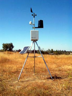
To the left, is an example of just one of the various types of weather stations, although all consist of the same tools.
Weather Stations are just like tracking the weather, only from different places. Each station transmits the weather back onto the computer to track storms, temps and help [us] track weather and transmit it back to you, for an EXACT look at the weather in YOUR area. It makes tracking weather easier.
To get a complete in-depth tour of what weather stations consist of, click HERE. This link will also be posted on our "CityWeather Links" column found on the left-hand side of the blog. This will tell you each of the instruments used in a weather station.
JULY RAIN TOTALS (for Toronto):
From the various CityNews Weather Stations across the G.T.A., [they] were able to collect July's rain totals for Toronto for various parts of the city.
Again, truth be told, July was a dry month and you may be surprised at the results.
RESULTS*:
Pearson Int'l Airport: 47.4mm
The average amount of rain at Pearson is 74.4 mm, respectably.
Caledon: 8mm
Newmarket: 9mm
Scarborough: 51mm
Ajax: 16mm
Oakville: 20mm
Mississauga: 31mm
Vaughan: 33mm
North York: 43mm
Brampton: 36mm
Thornhill: Did not record rain averages accurately this month.
*All measurements are calculated at a respectable average with courtesy of CityNews (http://www.citynews.ca/).
Keep in mind that I am headed on holidays Friday, so I will only be blogging tomorrow, and returning Wednesday. You are more than welcome to continue the emails.

Notice the "Links"?

Do you notice the CityWeather Links section on the left hand side? Generally each time I find a new link I'll update it (or for sure once every week). They actually have interesting links so check them out. You never know, you may enjoy them. And it makes blogging easier for me!

I'll have a weather blog later today so check back...just wanted to check oout the Links.


Chris city.weather@yahoo.ca

Tuesday, August 7, 2007

BEAUTIFUL LONG WEEKEND

Could we ask for a better long weekend? The weather was superb...but of course the Tuesday had to rain. Friday was nice...peaceful, and relaxing. Didn't go to bed until around 3:00am Saturday morning and woke at 9:30 am, no idea why. Saturday was peaceful. Of course, Saturday night had to be ruined at Yorkdale (Toronto). It's a great mall, don't get me wrong but it is sooooo busy. Sunday was also relaxing. Went to see my grandma (Mama) and mother .... nice BBQ. It was so nice--windy though. Monday I headed to work at my aunts and same for today. Well atleast Saturday and Sunday was peaceful with Monday of work.

But who cares about me...right?

Caribana Parade and the various events around Toronto went beautiful with the weather.

This week is looking good too.

There's no interesting weather to report in the forecast. But if you spot any, let me know right away through email. Please...

The radar imagery is also looking like it's clearing up so that's good.


Just a quick note.......I'll be off from Friday to Wednesday again. I will be back reporting on Thursday. But I'll still blog tomorrrow and Thursday.

If you have any weather links, click on CityWeather Links on the left side and enjoy!


Lot's of weather luck....


Chris
city.weather@yahoo.ca

Friday, August 3, 2007

LONG WEEKEND OUTLOOK

For those of us here in Toronto (and Canada for that matter), Simcoe Day or Civic Day is a holiday. And the outlook is looking fantastic for Toronto!!

That scorching heat and humidity is getting swept out by a cold front, even though, it will still be warm on Saturday with the high around the upper twenties. The air quality will be good to low moderate and the UV index will be quite high, too. The wind direction changes from southerly to northerly, which will make it feel drier than usual, while the AQI will be better. Sunday will be similarly beautiful with just some late day cloudy periods and a high near 28C. A weakening low could bring in some early morning showers for the holiday Monday but it looks like it's going to clear by the afternoon. A huge change will be in the overnight lows. Expect the temperature to drop to a seasonally fresh 17C on Saturday and Sunday mornings so shut down the AC and throw open the windows to enjoy the fresh air.

[Cottage Country]: For those of you up in Cottage Country, it will be cooler in the mornings. With temps on Saturday [morning] hovering around 14C and Sunday to 11C. Afternoons, however, looking great. Keep an eye out for highs around 27C and lots of sun across central Ontario on Saturday and Sunday. Monday brings in cloud cover with a slight risk of morning showers. Highs, though at 28C. Personally, I have no complaints about the long weekend...and we need at least one day of rain after this heat--good time to read, relax and recouperate.

I'll be off on Monday, but blogging again on Tuesday. Wishing everyone a safe and happy long weekend. Get some rest...we all need it!

Chris - city.weather@yahoo.ca

BREAKING RECORDS

We broke a record during TORONTO's 3-day heat wave, believe it or not.

First off, on Tuesday we reached a high of 33.8C. The record was set in 1975 with a temperature of 36.1C. We did, however managed to exceed the 2006 reading of 33.7C. Wednesday's temperature was at 34C. The record was set for 36.7 in 1995, while the 2006 reading was at 36.6C. So, compared to the past few years, Wednesday was cool.

Thursday was the record that we broke. We reached a high of 35C. The new record was Thursday (2007) at 35C. The old record was actually set in 2006 at 34.3C. Congratulations Toronto!

Later tonight around 9:00 pm (EST), I will have your long weekend Civic Holiday forecast and how it plays out. So check back.

Email me with your scorchering summer stories at city.weather@yahoo.ca . I will post them sometime next week.


Keep cool!

Chris

Weather Specialist

CityWeather

city.weather@yahoo.ca